
ACTIVATED Public Spaces
What makes a public space vibrant, walkable, and encourages people to dwell longer at different times of the day or night, and throughout the year?
Go to Challenge | 17 teams have entered this challenge.
Team Name:
Unlockable
Team Members:
Unlockable
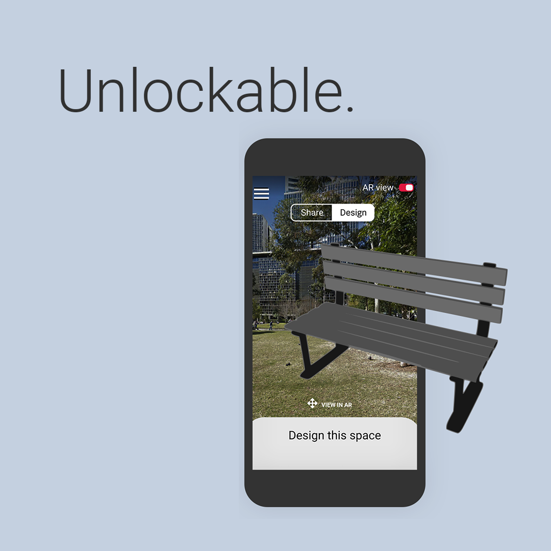
How can we better activate, enhance and unlock public spaces? To answer this question, the users of public spaces are the best people to ask, just what it is they love so much about their public spaces, and what needs improving. Unlockable is a web application that will do just that by unlocking local spaces and community stories through open-source data and Augmented Reality (AR). Unlockable is designed to be used in a transitory manner and by people currently spending time in a public space. Accessing Unlockable will be done by scanning a QR code in public spaces such as parks, art galleries, and libraries. Features that Unlockable holds includes:
Having looked into the datasets provided, we wanted data and information to be collected by the government and community. Creating use for both the government and the community. At its core, Unlockable facilitates this two-way data flow: it collects data for governments and communities and presents it back to communities in a way that helps inform decisions.
NSW Dept of Planning, Industry, and Environment provided a series of reports and tools used in the process of evaluating public spaces. We used the tools and reports to guide the creation of our solution. The evaluation options for the feedback form were drawn directly from the 10 principles as laid out in the NSW Public Spaces Charter.
Quantitative data was drawn from the challenges’ highlighted datasets from the NSW Dept of Planning, Industry and Environment, Transport NSW, and the Office of Local Government. We also used the Continence Foundation’s National Public toilet map (funded by the Federal Dept of Health) and Ausgrid’s streetlight map. Due to time constraints, data was not blended. For example, Transport NSW’s Car Park API fed directly into Unlockable to create one metric in Quick Stats. Publicly available mapping data from the toilet map and streetlight map will be linked to Unlockable via Google Maps integrations. A key issue encountered was data access privileges: although the urban vegetation and terrestrial biodiversity open data were available on the data portal, there was not enough time for team members to contact and directly request access to JSON files for Unlockable in the time period.
The datasets mentioned above were selected as they held the data points the team deemed most appropriate for enhancing users’ experiences in public spaces: toilet information, streetlight information, natural environment, and transport facilities.
Description of Use Referenced to align with NSW Government standards.
Description of Use We used this dataset to populate the "Green Space" stats in the Quick Stats section of Unlockable. Sharing urban vegetation data with users provides a quick snapshot of how green and covered their current public space is. Unlockable pulls from the shape file and geodatabase (found on the NSW ePlanning Data Portal) and links the location of the QR code to geographic data in the dataset to customise the "Green Space" figure. Linking public space data to urban vegetation data will assist governments in better activating and enhancing public spaces: if there is low urban vegetation, governments can pinpoint specific areas to target local gardening initiatives. If there is high urban vegetation, governments may identify vegetation to prune to enhance the safety of a space. Users can use this information to help select comfortable and welcoming public spaces to visit, particularly on hot, sunny days, or if they are exercising with pets.
Description of Use We used this dataset to populate the "Biodiversity" stats in the Quick Stats section of Unlockable. Sharing the terrestrial biodiversity of a location with users fosters a greater sense of appreciation for their local public spaces and local biodiversity. Unlockable pulls from the JSON file (as requested using the contact details found on the NSW ePlanning Data Portal) and links the location of the QR code to geographic data in the dataset to customise the "Biodiversity" figure. Linking specific public spaces to the terrestrial biodiversity present 1. provides governments with more information when trying to identify MORE public spaces, 2. provides governments with ideas on how to ACTIVATE existing public spaces (e.g. urban wildlife guided trails) and 3. whether the terrestrial biodiversity in a space is compromising or facilitating safe experiences in the space.
Description of Use Referenced to align with NSW Government standards.
Description of Use Referenced to align with NSW Government standards.
Description of Use Referenced to align with NSW Government standards.
Description of Use Our app helps users to understand where street lights are located in the app in AR mode, and users can be guided to this using the floating icons for the different facility and amenity types. Users can read about the number of street lights in the public space under about and quick stats. Understanding this data then helps users make informed decisions in the AR discover and design section, where they can choose to add in more street lights when redesigning the space, with this data then being fed back to the government to help inform future planning and ensure we create safer public spaces that are better lit. Similarly, users are then more informed when completing the survey about the space under community pulse and can then provide feedback on the current implementation of street lights.
Description of Use Our app helps users to understand where public toilets are located in the app in AR mode, and users can be guided to this using the floating icons for the different facility and amenity types. Users can read about the number of toilets in the public space under about and quick stats. Toilet data is used as part of our safety feature which is fixed on the screen at all times, as clicking the button helps users know where the nearest toilet is to hide in while they call the police if they fear they are in danger. Understanding this data then helps users make informed decisions in the AR discover and design section, where they can choose to add in more toilets when redesigning the space, with this data then being fed back to the government to help inform future planning. Similarly, users are then more informed when completing the survey about the space under community pulse and can then provide feedback on the current implementation of toilets.
Description of Use Our app shows users nearby facilities and quick stats in real time to help them better understand the public spaces they are in and then provide informed feedback in return about the use of public spaces through the community pusle survey. We have specifically usen the metrics for the number of pets, swimming pools, halls, libraries and hectates of public space. This has been shown under the about section where quick stats show this information in an accessible list view, or users can choose to see this in front of them in AR and also navigate to these sections using the AR functionality. Understanding this data then helps users make informed decisions in the AR discover and design section, where they can choose to add in more of these facilities and features when redesigning the space, with this data then being fed back to the government to help inform future planning. Similarly, users are then more informed when completing the survey about the space under community pulse and can then provide feedback on the current implementation of facilities and features.
Description of Use We used this API to show users the occupancy of car parks near by using AR, with the mobile application showing the occupancy in real-time in floating pop ups in front of them and also providing a line to the nearest car parks. Car park stats are also shown to the user under the about section and quick stats, which informs users of car parks near this space. Understanding this data then helps users make informed decisions in the AR discover and design section, where they can choose to add in more car parks when redesigning the space, with this data then being fed back to the government to help inform future planning of car parks or public transport in this area. Similarly, users are then more informed when completing the survey about the space under community pulse and can then provide feedback on the current implementation of car parks.
Go to Challenge | 17 teams have entered this challenge.
Go to Challenge | 14 teams have entered this challenge.
Go to Challenge | 9 teams have entered this challenge.